
 By Neil Kumar, Senior Product Manager at Ocient
On the heels of last week’s big OcientML™ announcement, the team at Ocient is thrilled to announce the launch of even more functionality with OcientGeo™, a new offering within our flagship product, the Ocient Hyperscale Data Warehouse™ (OHDW).
Geospatial data has become a critical driver of business value across numerous industries. In the advertising sector, companies need to pinpoint and analyze data using a multitude of factors such as demographic trends, physical store locations, and traffic patterns to deliver impactful and thoughtful brand experiences. In agriculture, farmers can use geospatial data to optimize irrigation, achieve precise seeding, and monitor crop health, significantly improving yield and reducing waste. Climate tech companies can use geospatial data to predict climate risk factors across a variety of sectors and use cases, and energy organizations can identify potential sites for renewable energy installations like wind farms or solar panels, leveraging data across landforms, wind speed, and sunlight exposure.
OcientGeo can assist with these and many other geospatial use cases by enabling continuous and complex analysis of geospatial data at volumes and speeds previously infeasible, providing your team with near-real time insights from the highest resolution spatiotemporal data available. To illustrate this, I recently recorded a demo to show how OcientGeo can help electric car manufacturers understand where to place charging stations in the Chicago area to ease their customers’ anxiety around range and battery life.
Watch My Intro to OcientGeo Video
What Makes OcientGeo Different?
OcientGeo enables enterprises and organizations to take their geospatial data analytics to the next level by leveraging previously cumbersome geospatial data sets to enrich their existing non-geospatial workloads, and to run pure geospatial workloads faster, and at higher resolution than ever before.
OcientGeo’s key features include:
- Support for High-Resolution Geospatial Data Types. With support for objects with up to 32 million data points each — that’s 50x better resolution than other spatial databases — OcientGeo delivers highly refined insights.
- A Truly Global Spatial Index.If you’re already analyzing geospatial data, you might be familiar with H3, an open source geospatial indexing system that partitions the world into hexagonal cells. H3 is great for land-based geospatial data. However, as we talked to customers, we learned they needed more. They needed an index to provide high-resolution data points across land, air, and sea. For that reason, we built a truly global index with support for data points anywhere on the globe.
- Native Support for More Than 120 Geospatial Functions. OcientGeo boasts the largest library of geospatial functions in the industry, giving you the tools you need to perform high precision, low-latency spatiotemporal analytics at scale.
And these features are first-class citizens in the already robust Ocient Hyperscale Data Warehouse which offers:
- Fast Data Loading. Thanks to our embedded extract, transform, and load (ETL) capabilities, your high-resolution data is ready for query within seconds.
- AI/ML Acceleration. OcientML places machine learning capabilities right in our SQL data warehouse, reducing the need for data movement and extra tooling and making it faster and easier to incorporate data science into your business processes.
- Integration with Leading Data Tools. Ocient systems are designed to be universally compatible. OcientGeo connects with a range of leading mapping and visualization tools like ArcGIS, QGIS, Carto, Superset, PowerBI, Metabase, Tableau and Jupyter.
An Example of OcientGeo in Action
Two of the core challenges we see with customers who want to do more with their spatiotemporal data sets are:
1. Loading geospatial data
2. Querying geospatial data at high resolution
As a result, organizations must downsample their data sets before they can load and query the data to generate geospatial intelligence. But, as you can imagine, compromising the fidelity of your data opens the door to missed opportunities and insights.
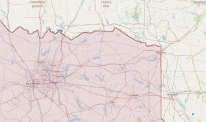
For example, with other spatial databases, the source data that makes up the Northeast Texas border (as seen below) would need to be downsampled to be loaded and analyzed resulting in the mapping of a low resolution image, with fairly blunt borders.
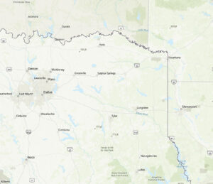
But with OcientGeo, data can be loaded quickly and analyzed at full resolution, delivering a more detailed border of the same section of Northern Texas as seen below.
OcientGeo: A Complete Geospatial Data Analytics Stack
OcientGeo is more than just a geospatial tool; it’s a comprehensive analytics solution for high-resolution spatiotemporal data. As an embedded component of the Ocient Hyperscale Data Warehouse, it enables users to leverage the full power of a SQL data warehouse, real-time indexing, in-database machine learning with OcientML™, and hyperscale ETL/ELT – all within a single, high-performance solution.
Along with the Ocient Hyperscale Data Warehouse, OcientGeo can be deployed on premises, on cloud, and in OcientCloud, bringing ultimate flexibility to your geospatial use case. And because Ocient’s entire data analytics stack leverages our Compute Adjacent Storage Architecture™ (CASA), OcientGeo delivers blazing fast performance at a fraction of the cost of computing with complex geospatial data sets within cloud data warehouses.
Don’t compromise on the quality and accuracy of your results, the predictability of your spend, or the flexibility and agility of your geospatial data analytics solutions. Streamline your entire geospatial data analytics stack with OcientGeo and experience efficient, cost-effective results like never before.
Join us on this journey as we revolutionize the world of geospatial data analytics. Reach out to schedule a demo and experience the OcientGeo difference today.